forum
library
tutorial
contact

Sensors Measure Power
in Waters of Admiralty Inlet
by Tom Paulson
Seattle Post-Intelligencer, September 20, 2007
|
the film forum library tutorial contact |
|
Sensors Measure Power
by Tom Paulson
|
PUD wants to find best place for tidal energy turbines
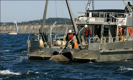 ADMIRALTY INLET, PUGET SOUND -- After a good bit of boat wrangling and repeated acoustic shots to release a device on the seafloor, researchers and energy officials were relieved to see a red buoy finally emerge on the surface.
"There it is," said Jeff Cox, an oceanographer hired by the Snohomish County Public Utility District. "I'm always happy when they come back up."
At the other end of a cable from the buoy was a 700-pound platform holding $45,000 worth of scientific equipment used to measure tidal currents. The PUD hopes to soon tap this water for renewable energy and the "acoustic Doppler current profiler" was deployed to tell them what they need to know.
"Essentially, all of Puget Sound flows through this channel," said Cox, who works out of Seattle for Evans Hamilton, a nationwide oceanographic consulting firm.
It's clear the tides run strong here, he said, but much more needs to be learned about the nature of the tidal flow in this waterway between Port Townsend and Whidbey Island before anyone starts dropping electricity-generating turbines into the water.
"To begin with, we'd like to know where the current is highest," said Brian Polagye, a tidal energy expert and graduate student in the University of Washington's Department of Mechanical Engineering.
The UW has a team of engineers and oceanographers working on tidal energy research in collaboration with the PUD.
In addition to finding the tidal current hot spots, Polagye said it's crucial to determine the shape of the tidal exchange. Some tides shift back and forth in a straight line, he said, while others flow in a more elliptical, or turbulent, pathway. All of that has to be factored in when designing a network of seafloor tidal turbines.
Once every 15 minutes for the past 30 days, the device has been using sonar to measure changes in tidal flow about every 10 feet from the surface to the seafloor, 250 feet below.
The data produced will require weeks of computer analysis at the UW.
The region's fervent exploration of tidal energy, along with a wave energy project proposed for Makah Bay in Clallam County, has been boosted by the voters' passage of Initiative 937 -- a measure that requires utilities to invest in renewable energy sources.
Snohomish County is looking at seven sites throughout the northern Sound with the aim of placing perhaps 1,500 tidal turbines -- basically, an underwater version of a wind turbine -- to produce 100 megawatts (or enough energy for 60,000 homes).
"We are a fast-growing county with something like 10,000 new customer connections every year," said Neil Neroutsos, spokesman for the PUD.
Tacoma Power is exploring tidal energy in the Tacoma Narrows and recently completed the same kind of acoustic testing. Tacoma, though its project is less ambitious than Snohomish PUD's, got the first federal permit to study tidal power.
"The computer model we're using seemed to show we had more energy than we expected, so that's a positive," said Scott Amsden, tidal energy project leader for Tacoma Power.
Related Sites:
P-I special report "Green Power: The New Generation" at seattlepi.com/specials/greenpower.
learn more on topics covered in the film
see the video
read the script
learn the songs
discussion forum