forum
library
tutorial
contact

The Four Lower Snake River Dams
Improving Salmon Passage, February 2002Army Corps of Engineers, Walla Walla District
|
the film forum library tutorial contact |
|
The Four Lower Snake River DamsImproving Salmon Passage, February 2002Army Corps of Engineers, Walla Walla District |
 The Snake River is the principal tributary to the Columbia River, draining approximately 109,000 square miles in Idaho, Wyoming, Utah, Nevada, Washington, and Oregon. Flows in the lower Snake River are highest in the spring (average annual peak of approximately 165,000 cubic feet per second) and lowest in late summer (averaging 25,000 cubic feet per second).
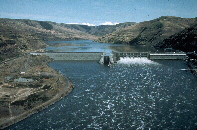
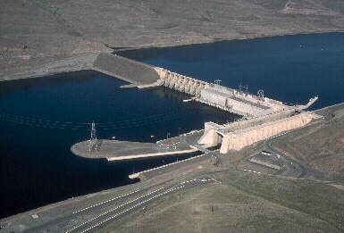
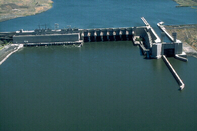
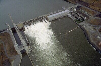
The Lower Snake River Project features four locks and dams in the state of Washington: Ice Harbor Dam, Lower Monumental Dam, Little Goose Dam, and Lower Granite Dam.
The dams became operational between 1961 and 1975.
The four dams are all run-of-river facilities, which means that they have limited storage capacity in their reservoirs and pass water through the dam at about the same rate as it enters the reservoir.
All four of these dams are multiple-use facilities that provide navigation, hydropower, irrigation (pumped from reservoir behind Ice Harbor Dam), recreation, and fish and wildlife conservation benefits.
These dams were not built to control floods.
The Snake River is the principal tributary to the Columbia River, draining approximately 109,000 square miles in Idaho, Wyoming, Utah, Nevada, Washington, and Oregon. Flows in the lower Snake River are highest in the spring (average annual peak of approximately 165,000 cubic feet per second) and lowest in late summer (averaging 25,000 cubic feet per second).
The Lower Snake River Project features four locks and dams in the state of Washington: Ice Harbor Dam, Lower Monumental Dam, Little Goose Dam, and Lower Granite Dam.
The dams became operational between 1961 and 1975.
The four dams are all run-of-river facilities, which means that they have limited storage capacity in their reservoirs and pass water through the dam at about the same rate as it enters the reservoir.
All four of these dams are multiple-use facilities that provide navigation, hydropower, irrigation (pumped from reservoir behind Ice Harbor Dam), recreation, and fish and wildlife conservation benefits.
These dams were not built to control floods.
Juvenile fish from the lower Snake River drainage system may have to travel past as many as eight Federal dams before reaching the Pacific Ocean.
| Lower Granite Dam | Little Goose Dam | Lower Monumental Dam | Ice Harbor Dam | |
|---|---|---|---|---|
| Miles from Columbia River |
107.5 | 70.3 | 41.6 | 9.7 |
| Construction Date | 1975 (units 1-3) 1978 (units 4-6) |
1970 (units 1-3) 1978 (units 4-6) |
1969 (units 1-3) 1981 (units 4-6) |
1962 (units 1-3) 1976 (units 4-6) |
| Normal Operating Pool Elevation | 733 - 738 feet | 633 - 638 feet | 537 - 540 feet | 437 - 440 feet |
| Maximum Pool Elevation | 746.5 feet | 646.5 feet | 548.3 feet | 446.0 feet |
| Power House Hydraulic Capacity | 130,000 cfs | 130,000 cfs | 130,000 cfs | 106,000 cfs |
| Power House Nameplate Capacity | 6 @ 135 MW 810 MW total |
6 @ 135 MW 810 MW total |
6 @ 135 MW 810 MW total |
3 @ 90 MW 3 @ 111 MW 603 MW total |
| Power House Overload Capacity | 6 @ 155.3 MW 932 MW total |
6 @ 155.3 MW 932 MW total |
6 @ 155.3 MW 930 MW total |
3 @ 103.5 MW 3 @ 127.5 MW 693 MW total |
| Spillway | 512 feet 8 gates |
512 feet 8 gates |
572 feet 8 gates |
590 feet 10 gates |
| Maximum Spillway Design Capacity | 850,000 cfs 19.5 acre*feet/second |
(?) | (?) | (?) |
| Reservoir Name | Lower Granite Lake | Lake Bryan | Lake Herbert G West | Lake Sacajawea |
| Reservoir Length | 39.3 miles (Snake) 4.6 miles (Clearwater) |
37.2 miles | 28.7 miles | 31.9 miles |
| Shoreline Length | 91 miles | 92 miles | (?) | (?) |
| Reservoir Width | 0.3 miles (avg.) 0.6 miles (max) |
0.4 miles (avg.) 0.8 miles (max) |
0.4 miles (avg.) 0.8 miles (max) |
0.4 miles (avg.) 1.0 miles (max) |
| Reservoir Surface Area | 8900 acres | 10,025 acres | 6,590 acres | 8,375 acres |
| Reservoir Storage | 483,800 acre-feet (elev. 738) 440,200 acre-feet (elev. 733) |
565,200 acre-feet (elev. 638) 516,300 acre-feet (elev. 633) |
20,000 acre-feet (between 537 & 540 feet elev.) |
24,900 acre-feet (between 437 & 440 feet elev.) |
| Abutment Embankment | Gravel fill w/ rock facing, impervious silt core Top width 45 feet, Slope 1V on 2H |
Gravel fill w/ rock facing, impervious silt core Top width 43 feet, Slope 1V on 2H |
Length: 968 feet (north shore) 1,075 feet (south shore) |
Length: 624 feet (north shore) |
| Dam Length | 3200 feet | 2655 feet | 3791 feet | 2822 feet |
| Dam Height | 100 feet | 98 feet | 100 feet | 100 feet |
learn more on topics covered in the film
see the video
read the script
learn the songs
discussion forum