forum
library
tutorial
contact
Hardiness Map Shifts with Climate
by Dave WilkinsCapital Press, August 17, 2007
|
the film forum library tutorial contact |
|
Hardiness Map Shifts with Climateby Dave WilkinsCapital Press, August 17, 2007 |
USDA contracts with OSU to update the 1990 version
 Anyone with a green thumb is familiar with the U.S. Department of Agriculture's plant hardiness zone map.
Reproductions of the color-coded map often appear on the back of seed packets sold at garden centers, in the seed catalogs that arrive in the mail and on plant identification tags.
The purpose is simple: to serve as a guide to which plants will grow in a particular region.
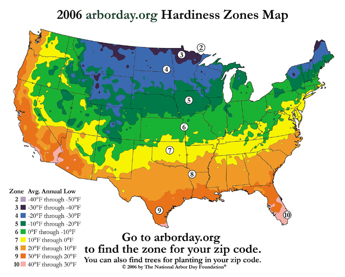
The map shows 10 zones, ranging from the coldest (Zone 1) to warmest (Zone 10).
The current version of the map, released in 1990, is at www.usna.usda.gov/Hardzone/.
USDA has contracted with Oregon State University to produce an updated version using its PRISM climate modeling system, a technology developed by OSU researcher Christopher Daly.
The project is expected to wrap up sometime next year.
In the meantime, some more recent climate zone maps are available through groups such as the National Arbor Day Foundation and the Sunset Western Garden Book.
The National Arbor Day Foundation recently completed an extensive updating of U.S. hardiness zones, based on data from 5,000 National Climate Data Center cooperative stations across the continental U.S.
The updated 2006 map reflects a warmer U.S. climate compared with the 1990 version. Both can be viewed at the foundation's website, www.arborday.org.
Many regions in the updated map have jumped a zone or two from the 1990 version.
In the 1990 map, for instance, most of Central Idaho was in Zone 4. In the 2006 map, it's in Zone 5.
Hardiness zone maps are intended as a general guideline as to which plants will survive where, but they don't tell the whole story. There are many other factors to consider.
"The (USDA plant hardiness) zones are a good starting point, but you still need to determine for yourself what will and won't work in your garden," the folks at www.backyardgardener.com point out.
"For example, although both Austin, Texas, and Portland, Ore., are in the same zone (8), the local climates are dramatically different," they advise.
Soil types, rainfall, daytime temperatures, day length, wind, humidity and heat also play a role.
"Hardiness ratings alone are inadequate to guide landscapers in selecting the most successful plants," the USDA advises gardeners on its website.
Gardeners should keep the following factors in mind when using hardiness zones to select a suitable environment for a landscape plant, according to USDA:
learn more on topics covered in the film
see the video
read the script
learn the songs
discussion forum