forum
library
tutorial
contact
Tearing Down the Past
Builds Healthier Future for Wetlands
by Katie Wilson
Daily Astorian, July 12, 2011
|
the film forum library tutorial contact |
|
Tearing Down the Past
by Katie Wilson
|
National Park Service restores sites at Otter Point, Fort Columbia
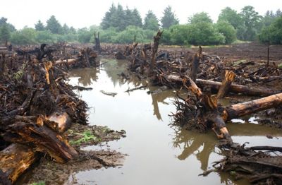 Last year, both sites looked like war zones, with a violent uprooting of trees and plants, torn ground, mud everywhere.
Today, Otter Point (Lewis and Clark National Historical Park in Astoria) and a site at Fort Columbia (in Washington) are looking more how staff from the National Park Service and the Columbia River Estuary Study Taskforce (CREST) envisioned they would months and months ago.
"It was pretty scary there at first," said CREST Director Micah Russell about Otter Point. "Now you can really visualize what the wetlands are going to look like."
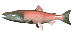
Both projects, intended to benefit salmon, involve the reintroduction of tidal flow across historic wetland areas.
With the federal push to protect salmon, restoration projects like those at Fort Columbia and Otter Point are getting more attention. The data collected at Fort Columbia, for instance, will be valuable in guiding projects as the site monitors look at how salmon respond to and benefit from the reopened habitat.
Multiple goals are folded into the projects: restoration of historical wetland that has (in some cases) been cut off from the water for decades, habitat and wildlife preservation, and quality of life for nearby human populations.
Reopening the wetlands by breaching a dike at Otter Point means the city of Warrenton is getting a new dike. Built on the National Park Service's dime, it will be the only dike in a sprawling and increasingly worn-out system that will be constructed to the new U.S. Army Corps of Engineers' standards.
At Fort Columbia, returning the wetlands to their original state will probably (and to a certain degree already has) cut down on flooding issues in that area.
But for all the potential benefits, restoration work can look destructive in the beginning stages.
At Fort Columbia, bringing back the water meant major work on a major highway: replacing a small 24-inch culvert under U.S. Highway 101 with a massive 12-foot-by-12-foot culvert.
At the considerably larger Otter Point site, crews with Henderson Land Services systematically took the land apart: clearing out dredge spoils, tearing up most of the existing landscape to bring down the elevation, carving out historic channels and beginning construction on a massive dike.
Now, Otter Point is at the end of the first phase of its two-phase development. Project managers Matt Van Ess, with CREST, and Carla Cole, with the National Park, couldn't be happier. "This is a major milestone," Van Ess said, looking around at the still very muddy site, the tidal channels bordered with salvaged woody debris. "(This is) three years of design work and permitting."
The project had several setbacks, including concerns from Warrenton city officials and then the crash of a small single-engine plane on the site, not to mention the sheer amount of work it took to clear the grassy, wooded area.
The Fort Columbia site has been finished for several months and already seems to be fulfilling its purpose although it's still too early to say for sure.
"In all our seines (nets), we caught at least as many fish as we had last year so, already, it's a huge increase in the amount of fish we're seeing," said April Cameron, a biologist and ecologist with CREST, who is one of three people actively monitoring the Fort Columbia site.
Since March, they have counted, among other fish, 174 Chinook salmon and 64 Coho.
The site monitors trap fish in nets and weigh them and count them. There is a PIT tag array set up. Using this, monitors can track juvenile salmon movement and behavior, Cameron said. PIT-tagged fish can provide monitors with a wealth of information for comparison such as the weight and length of a salmon at the time it was tagged.
It's not all about fish though. Site monitors note down everything: how the tides are affecting the landscape and are carving out channels, bringing in debris, encouraging or discouraging particular plant growth; what animals are using the area and how they're using it. The list goes on.
"We're just beginning," Cameron said.
learn more on topics covered in the film
see the video
read the script
learn the songs
discussion forum