forum
library
tutorial
contact
Tug's Trip Along Snake and Columbia Rivers
by Jamie FrancisThe Oregonian, September 17, 2012
|
the film forum library tutorial contact |
|
Tug's Trip Along Snake and Columbia Riversby Jamie FrancisThe Oregonian, September 17, 2012 |
Watch time lapse video and excellent photo essay at original site.
 It's 3:27 in the morning and the jaws of the Columbia River are closing around Lloyd McCelland. Only moments before the river was placid, but McCelland knew it wouldn't hold. It never does.
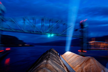
McCelland is halfway into his six-hour watch as pilot of the tugboat Kathryn B, guiding three giant barges that make the tug and her tow longer than two football fields. Downriver, the Celilo Railroad Bridge and its eight steel trusses is a foreboding obstacle, darker than the night sky. This new mood on the Columbia -- born, it seems, from the upcoming bridge -- has brought a tense silence to the wheelhouse.
McCelland, a pilot for Bernert Barge Lines in Oregon City, is on a regular run from Lewiston, Idaho, on the Snake River to the Port of Kalama on the Columbia. Bernert Barge Lines, a family operation that has served the Columbia, Snake and Willamette rivers since 1887, operates four boats. They haul mostly sand, gravel, wood chips, logs and scrap metal. The company's boats are smaller than other outfits on the river and its crews see themselves as the underdogs.
McCelland and three other men will operate the Kathryn B around the clock on a seven-day shift. They sleep and work -- six hours at a time -- until their rotation on the tug is complete. By the time this three-day segment of their rotation is done, they will have been up and down parts of two great rivers. They will have navigated the four dams and locks on the Snake and the four dams and locks on the Columbia. They will have been burned by the sun, pelted by the rain and battered by the wind. They will have endured lightening and enjoyed rainbows.
The river is a living to these men and others like them, but it's also a home. Rocks have names, bends in the river have stories. These men are the keepers of those tales. They speak a language that has been passed down to them: They build tow. They turn the water around. They get their go-ahead stopped and their swing going.
There is monotony to this life on the river, but it should not be mistaken for security. The river may be slow to change but it rarely behaves the same.
A few hundred yards upriver from the Celilo Railroad Bridge, the main channel of the Columbia makes a turn toward the Oregon bank. The rocky shore is a stone's throw away before the channel turns. It's a reminder that the deepest part of the river is not always the middle. The Columbia bends back north away from the Oregon shore just before the bridge.
This morning, the current is pushing the Kathryn B and her nearly 7,000-ton load toward the rocks. McCelland, perched 52 feet off the water, can't see exactly what the water is doing but he knows it is cutting fast into the bank and it is taking the Kathryn B with it. McCelland is standing now, leaning toward the glass of the wheelhouse trying to factor in as many landmarks as he can through the darkness.
The tug, running on diesel-powered twin engines, is moving at about 7 1/2 mph. McCelland committed to his bridge approach several hundred yards back, and he's not sure if he has miscalculated. If he has, there is no going back -- too much barge for that.
McCelland needs to guide the Kathryn B through a 300-foot opening in the middle of a turn. He'll have to do it in the dark with the water doing something that he's never felt before. The tug is equipped with radar, GPS and the latest navigation systems, but this move is performed by gut feeling. Navigating by Braille is what McCelland calls it later.
The Celilo bridge passage was not made for easy navigation. It requires more of a slide than a turn, and if McCelland hits the pass like he wants he will use most of the 300-feet opening. It's a complicated calculation that requires a pilot to account for boat speed, barge weight and size, weather, time of day and maybe most of all, what the water is doing.
McCelland steers the bow toward the bridge using a series of markers that never move; a rock, a mountain, the land's contours. Well into the maneuver, he sets his sights on the red light on top of the north pier. He knows about where he needs to be with respect to the red lights that mark each pier. There is also a green light, dead center of the hole through which McCelland is supposed to guide the Kathryn B. Experience will tell him when to begin the slide-and-turn maneuver that will keep his stern off the south pier. Slide and turn, he mumbles. Slide and turn.
The Kathryn B is indeed almost sideways coming under the bridge. McCelland exhales as the stern clears the pier and the silence is broken. The river, flowing unhindered by bridge piers, is quieter now. McCelland begins to talk as the bridge fades into the cobalt sky. The first hint of sunrise is giving the land definition. McCelland leans back and continues with a story about Alaska.
learn more on topics covered in the film
see the video
read the script
learn the songs
discussion forum