forum
library
tutorial
contact

How the Waterfront Went from a Shit-Filled
Disaster to Portland's Real "Living Room"
by Joe Streckert
Portland Mercury, April 29, 2015
|
the film forum library tutorial contact |
|
How the Waterfront Went from a Shit-Filled
by Joe Streckert
|
 EVEN WHEN IT'S SHROUDED in a fine layer of mist, someone is always out enjoying Portland's waterfront. People are jogging, walking their dogs, looking at the river, or tapping their cigarette ashes into the water below. On sunny days, it's a riot. Pedestrians, bicyclists, punks, street musicians -- a whole panoply of humanity clusters around the Willamette.
"They call Pioneer Courthouse Square the 'Living Room' of Portland," says Doug Kenck-Crispin, the man behind the popular Kick Ass Oregon History podcast. "But I think you'd be hard-pressed to find something more beloved and well known than the waterfront."
Despite its current adored status, Portland's waterfront hasn't always been so beloved. It used to be an avenue of decay, decadence, and literal shit. Only in the latter part of the 20th century did the city actually have a riverfront where a normal human being would want to spend time. For much of Portland's history, the river was something to be quickly passed over -- not gazed into.
The First Wharves
Before Waterfront Park came to be in 1978, before Harbor Drive opened in 1943 -- before any of that -- Portland's waterfront was seen as a major commercial asset. A port would make the city an actual hub of commerce rather than just another lonely Western town. From Portland's beginning in 1851, there was a rush to build wharves and docks to foster lucrative maritime trade.
This infrastructure sprint nearly resulted in two Portland mayors coming to blows. Former Mayor George Vaughn attempted to construct a wharf in 1859, and city council ordered him to stop.
"They were fighting over whether the city owned the strip along the river or whether individual organizations did," says Finn J.D. John, author of Wicked Portland.
"The sitting mayor [Stephen McCormick] didn't want it and got Vaughn [legally] served to stop working on his pier." Vaughn refused. "[He] had a huge crew working on this thing, and the mayor went down with a large mob on his heels and together they dismembered the offending wharf," John says.
Despite this setback, private enterprise would eventually win out when it came to wharf building. But private ownership of the docks meant that maintenance was sporadic, at best.
"You'd build your dock and then you'd maintain it or not," says John. "The river flooded every year, so they were always in a terrible state of repair. It was a fairly unappealing place."
"The Head of Navigation"
Even aside from crumbly docks, making Portland into a port town was hugely problematic. Portland is commonly thought of as the "head of navigation" (the farthest point upstream that large ships can travel), but according to Barney Blalock, author of Portland's Lost Waterfront, that just wasn't the case back in the day.
"The Willamette River used to go 20 feet up and down," says Blalock of how much the water level would vary throughout the year. "It was a shallow river in a lot of places. That's not the picture we get when we hear the encapsulated Portland history, where John Couch said this was the head of navigation."
Blalock's theory is that Portland became a commercial center with an active industrial waterfront only after all manner of wrangling, boosterism, and general political positioning ensued.
"There was a big huge push in 1890 for 'Portland to the Sea,' which was a big slogan of the time," says Blalock. "They were starting on the Panama Canal, and Portland didn't want to miss out."
Blalock credits Oregon Senator H.W. Corbett for doing the politicking and dealmaking necessary to get the Columbia and Willamette Rivers dredged. That made Portland's port and waterfront possible in the first place. Commercial activity flourished here far inland, instead of Astoria -- which in many ways was the more logical choice for a port city.
"Astoria thought it was going to be San Francisco even as late as 1890," says Blalock.
"[Portland] is where the infrastructure was, where the customs house was -- lots of other bureaucratic traffic was associated with shipping," says Kenck-Crispin. "But much of the time, the loading of goods onto ships happened in other locations due to the height of the river." While, in practice, Portland was a pain as a port, it had the infrastructure necessary to bring in trade, money, and tons of sailors.
Meanwhile Astoria, which is actually near the Pacific Coast, never got to be San Francisco.
River of Filth
Compounding Portland's awkward status as a port town was the frequent flooding, which would cover the city with a layer of water and waste.
"There's the flood of 1894," says Kenck-Crispin, referring to a flood that raised the water level of the Willamette to approximately five-and-a-half feet above Downtown's streets. "That's the big kahuna of them all, but flooding happened every goddamn year. Not to the over-30-feet level, of course, but they had to build the seawall to keep shit out of the streets."
Kenck-Crispin means "shit" in an entirely literal way. The city dumped its waste and effluents into the Willamette, and so did the rest of the Willamette Valley upstream.
"Something that never gets mentioned," says Blalock, "is that Portland wanted a buffer between the city and the river. The river stank. It stank like a sewer."
Despite the obvious stench, though, a person from the late 1800s or early 1900s would have viewed the state of the Willamette differently than a modern person.
"I don't think people saw it as polluted until much later," says Sy Adler, professor of urban studies and planning at Portland State University. "The idea was this was a bustling, productive area. Money was being made. If that meant not having access to a clean waterfront -- well, that didn't become an issue until much later."
Productive or not, Blalock and Kenck-Crispin note that until the mid-20th century, the Willamette was not a place you particularly wanted to be near. The smell of waste permeated the air around Portland's waterfront, and so the areas immediately near the river became low-cost, low-status neighborhoods. The nicer homes on the Westside were set back to deep Northwest Portland, out of the blast radius of the profitable (but disgusting) river. The district near the port was reserved for the working class, the people who actually made all that commerce work.
"The Sons of Neptune"
Portland's Old Town -- now a hybrid skid row and clubbing district -- was formerly an area for transient, mostly male workers to live and find jobs in seasonal industries such as agriculture, lumber, and (especially) shipping. Blalock notes that Old Town -- which wasn't called "Old Town" in the 1880s, but rather "Couch's Addition," "the North End," or "Whitechapel" -- was economically and demographically separate from the rest of Portland.
Old Town has always, in one way or another, been a somewhat ostracized part of Portland; before today's homeless population and dilapidated buildings became a common sight, it was the domain of saloons, gambling dens, and low-rent boarding houses. In his book Portland's Lost Waterfront, Blalock colorfully notes that the North End often got "breezy" when "the Sons of Neptune" were in town (his description of drunken, whoring sailors).
"I get the feeling," says Blalock, "from all the thousands of newspapers I've read, that Portland liked to ignore the business of the port."
Scowtown and the Boneyard
In the early 1900s, the Willamette River was the home of a scowtown -- a host of floating houses -- and a graveyard for dilapidated ships called the Boneyard. Blalock describes the floating shacks, or scows, as made of boards, lumber mill leavings, spare planks, and anything else that residents could get their hands on to construct a slum on the river.
"[The Boneyard] was a little further down the river than Union Station," says Kenck-Crispin, "and it was where all the old boats would go. Some of them they'd repair, and others would get junked and just float out there. And there were lots of people who were living on the boats. They would also take boards off the boats to make hovels.... There was one police report about a fight in the Boneyard over a bucket of beer. And I just picture a bucket of beer in the Boneyard as being really gross."
Despite the river being filled with waste and raw sewage, living on a floating hovel had the advantage of being cheap.
"They didn't have to pay any taxes or anything," says Blalock of the Willamette's floating residents. "It was kind of a freebie place to live."
Decline of the Wharves
"Things were starting to look a little raggedy by the end of the [18]80s," Blalock says. "[Industry] started moving to where they had more room."
Blalock also notes that much of the original docks and wharfs were too small for the level of commerce that started going through Portland at the turn of the century. Large grain elevators in Albina could load ships quickly and efficiently, and much of the old wooden wharves were left to rot. Things picked up even more so in the 1910s.
"What really put Portland solidly on the map," says Blalock, "was WWI. The Germans were sinking ships like crazy in the Atlantic, the Panama Canal was open... and all these shipbuilding companies moved into Portland and started hiring people. The '20s is when everything really changed."
And in that decade, the waterlogged, dilapidated, and sometimes shit-covered commercial infrastructure that had formerly been the main pillar of Portland commerce was destroyed.
The Highway
Proposals to replace the docks with something a little less ramshackle date from early in the 20th century. In 1903, the Olmsted firm (the landscape architects behind Central Park and Portland's own Park Blocks) advocated for more parks in the city, and in 1912 a proposal called the Bennett Plan called the wooden wharves a "menace" and proposed that "the river roadway is the most natural and economical for traffic circulation," though the report also emphasized green space near rivers.
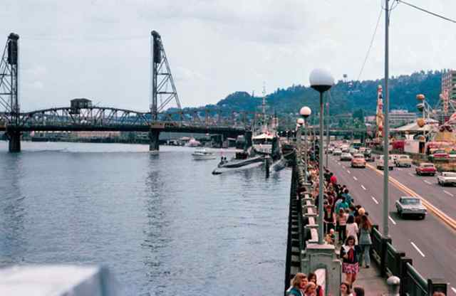
According to Blalock and Kenck-Crispin, the waterfront was not yet seen by Portlanders as a source of leisure or urban adornment, but much more of a utility space. Building a highway was a far more intuitive progression than transforming a stinking bed of commerce into a park. Instead, the industrial zone was replaced with a highway. In 1943, Harbor Drive connected Barbur Boulevard to the Broadway Bridge, which then snaked onto Interstate Avenue. Portland's downtown, long insulated from the water by industry, was now cut off from the Willamette by traffic.
The highway was only active for a few decades. In 1968, a mere 25 years after its construction, Governor Tom McCall convened a task force to look into replacing the road with a public green space. At the same time, pollution in the Willamette had decreased dramatically, making the waterfront more desirable. In 1950, the Oregon State Sanitary Authority took measures to prevent pulp mills from dumping into the Willamette, and McCall helped create the Oregon Department of Environmental Quality in 1969, tasked with enforcing environmental statutes.
According to PSU's Adler, the idea of replacing Portland's riverside highway with a park fit neatly into a larger wave of new urban thought in the 1960s and '70s.
"There was a whole anti-freeway movement throughout the United States originating in San Francisco," Adler says. "Freeway revolts happened in lots of different places."
Not everyone was enthusiastic about destroying the highway. Don Bergstrom, a traffic engineer at the time, was initially appalled by the plan. In a 1995 interview, urban planner Richard Ivey quotes Bergstrom as saying, "this will back cars clear up to Lake Oswego."
However, according to Adler, skepticism about the plan melted away when the relevant authorities endorsed Harbor Drive's destruction. "I don't think there was much opposition once Glenn Jackson, the head of the highway commission, was on board," he says.
Then in 1973, two new freeways obviated traffic issues in Portland.
"They built I-405 on [the west] side and I-5 on [the east] side," says Adler. "So it was pretty easy, in that sense, to let downtown go because downtown would still have a great deal of accessibility."
In 1974, a year after I-405 was completed and traffic completely flowed around the outside of downtown, Harbor Drive was destroyed and construction on Waterfront Park began.
The Oregonian was reluctantly on board with the project. "The closure of Harbor Drive on the west bank of the Willamette River in downtown Portland will cause considerable traffic dislocation and probably, at least for a time, traffic confusion and inconvenience," wrote the editorial board in May of 1974. "But, in the long view, it is the thing to do."
Predictions about traffic jams, congestion, and other issues, though, turned out to be ill-founded. When the waterfront highway closed, the existing roads turned out to be sufficient for Portland's traffic needs.
Bergstrom, the engineer who thought that traffic would be backed up from Portland to Lake Oswego, was surprised. In the previously mentioned interview, Ivey quotes him as saying, "They closed Harbor Drive today and there wasn't even a ripple."
The park that sits next to the Willamette River today opened in 1978.
On the Waterfront
The modern waterfront would shock Portland's founders, past boosters, and former elites. They expended all manner of money, influence, and effort to turn the banks of the Willamette into a commercial enterprise, and now it's a leisure space. The idle state of the waterfront, the idea that a river could provide mere beauty and nothing else, would have been unthinkable a century ago.
"I think a person from the 1880s would go, 'Where's your industrial center? Where's your commerce?'" says Kenck-Crispin, "'How does this town live? Because you're not using the river.'"
learn more on topics covered in the film
see the video
read the script
learn the songs
discussion forum